DMZ -- Korean Demilitarized Zone

In CHEETAH print = )

As you are driving along the road, you begin to see barbed wire and these posts off in the distance.
The DMZ is lined with 2 sets of bared wire and guard posts.
These guard towers are to patrol the boarder. In the tower is at least one man, who is heavily armed.
Imjingak
Our first stop on the DMZ tour was Imjingak. This is literally a place of ruins, when the two sides decided to make the DMZ/boarder, many families were pushed out of their homes (which may have been in that area) and told to go to one side of the other. Many families were broken up, some living in North Korea and some in South. Now Imjingak serves as a place for those families to go and pray for their loved ones or ancestors which were torn from them due to the creation of the DMZ.


As sad as this place was, Scott and I stopped to take a picture next to this statue of a woman guard.
(And thank goodness we did, you can see in the background the 'Freedom Bridge')
At the end of the bridge, people wrote/write on ribbons
about their sentiments for unification between the two countries.
(Below pictures)


The Freedom Bridge was last used to exchange prisoners of war during the Korean War.


This is the discounted Kyongui rail line that once went between North and South Korea.
Posted below the train reads: "The Train Wants to Run"
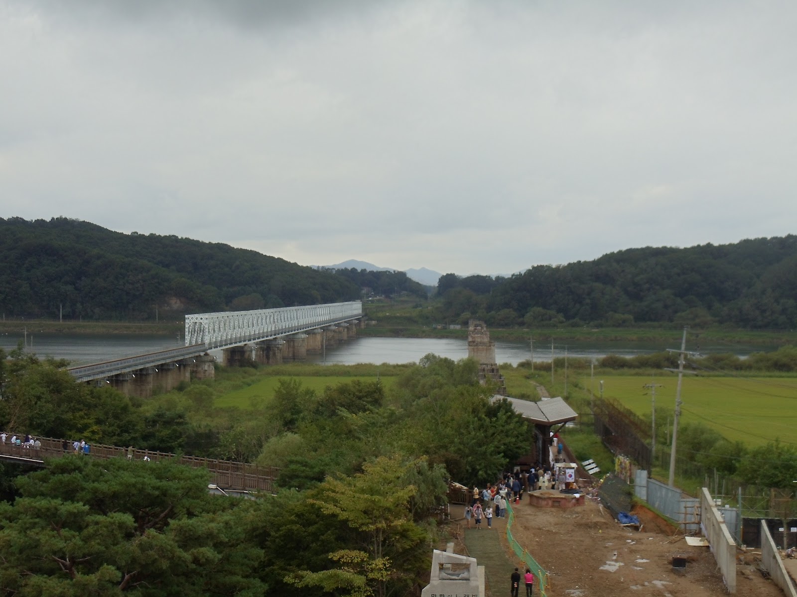

Actually you can see the new rail line that was built, however, it does not connect to North Korea.
This line runs right into the next village and supplies the area with necessities, but they are unable to trade with North Korea.

We were lucky enough to see a train go by on its way to the next village within South Korea.


One of my FAVORITE pictures from the DMZ trip. ---------------------->
The pictures shows the ruins of the Kyongui Line and then the new rail line, ready to be used for transportation between North and South.

Along the barbed wire at Imjingak, people were able to
write their hopes for unification or peace on the ribbons again.

One of the temples placed for people to come and pray for their loved ones or lost ancestors.


(right) Scott and me checking it out from the top view.
(left) Aerial view of the ruins of the Kyongui Line.
Tongilchon (no pictures)
Next we stopped at one of the last villages between North and South Korea, Tongilchon. It is located in the DMZ so people living within the area live a very safe life (heavily guarded). As you drive through, you do not see any gates or addresses on houses. Residence of Tongilchon do not pay taxes nor do they 'buy' their land. Much of the land was either theirs to begin with or has been given to them by the government. This area is rich in rice, soybeans and Jinseng. To remain a citizen of Tongilchon, you have to physically be present 100/365 days of the year. Let's be clear, this is a small village. To reference my home area, it is about the size of Ringsted. Pretty much forcing the younger generation to make the decision to live in Tongilchon or get an education.
While we were here, we ate the local food of "soybean soup". I was actually very excited for this because of my recent discovery and LOVE of edamame (which I cannot find in Korea!! SAD FACE)..... Let's just say it was NO edamame!
The Third Tunnel

Sign outside of the museum for the tunnels.


Inside at the museum was a glass floor depicting the terrain of the DeMilitarized Zone. It illustrated how the boarder runs along the river and then starts to peak up northward.

At one time, each post had a North Korean Soldier and South Korean soldier standing on their side of the barbed wire.
These soldiers saw each other every day, they never talked, yet North Korea was afraid,
that if the time ever came to shoot the South Korea, they wouldn't because of the bond they had formed. Thus they removed their soldiers and began making look out posts.

This depicts how the different tunnels were made, their depth and also the incline.


As you can see, there have been four attempted tunnels that have been built (and found) to access South Korea. The South Korean Army believes there may be up to twenty different tunnels that have been built along the DMZ.
Why tunnel you may ask?
Well, we were allowed to hike 300 meters (roughly 25-30 stories) down at a 15 degree angle to see why "a tunnel."
The third tunnel was discovered in 1978. South Korea was tipped off about the presence of a tunnel by a North Korean spy. Upon discovery the tunnel was 6.5 feet x 6.5 feet. It was dug 240 feet below the surface. It was built at that size and depth so that 10,000-30,000 North Korean military troops could be to Seoul in less than an hour (unobserved).
And THAT my friends is WHY YOU TUNNEL.
The walls of the tunnel were lined with coal so that if it ever was discovered they could claim that it was just an old coal mining tunnel. However, North Korea denies ever having part in the creation of the third tunnel and actually believes that South Korea made it to infiltrate North Korea.


Outside of the tunnel is this statue depicting the importance
of unification of North and South Korea to the world.
Dorasan Station
Actually, Dorasan Station was my favorite part of the trip. It really showed what kind of hope the South has for unification between the two countries. Dorasan Station was built in full preparation for the opening of the boarder between North and South Korea in 2001, however, it all fell through. Currently the station runs one line to Tonggeun (most norther village in South Korea).
In 2007, the boarder was open and the station was able to run raw material into North Korea and bring out finished goods. However, a year later a disagreement between the two counties, again, closed the boarders.


"Not the last station from the South.
But the first station toward the North."

Commuter train departing for Tonggeun.
We were able to purchase a ticket (which I did).
Hopefully some day I can say I remember when.... while looking at that ticket stub.


Best part.... being able to play on the tracks. Yes, ladies and gentlemen, they allowed us to just horse around on the tracks of an actual running train.....never in the US.


Ellie (the other girl teacher at my school) and me on the tracks. (left)
Scott and me goofing around seeing who could balance the best.... he won. (right)

So you were allowed to play around on the tracks, but not without being watched by the 19 year old guard.


We were allowed to go on the other side of the platform, which is currently not in use.
It was super eerie. Weeds were grown up along the platform, windows were just propped on the ground waiting to be installed and the escalator went down to... nothing.
It was actually very sobering to know that this place has been locked in time for the past ten years waiting for unification or at least peace between the two nations.


These two pictures aren't the best, but we were in the bus at this time. These pictures show the immigration/customs area for the future North Koreans getting off at the station.
Everything is built, just waiting for that day.
Observatory of North Korea
At this time, we came the closest to North Korea. We were within one km of their shore. North Korea has different "propaganda villages" set up along the boarder to "fool" South Korea into thinking they are more prosperous than what they really are. These villages have very nice homes, equipped with electricity. However, you seen NO movement in these villages every and the lights all come on at the same time, illustrating that they must be run on a timer.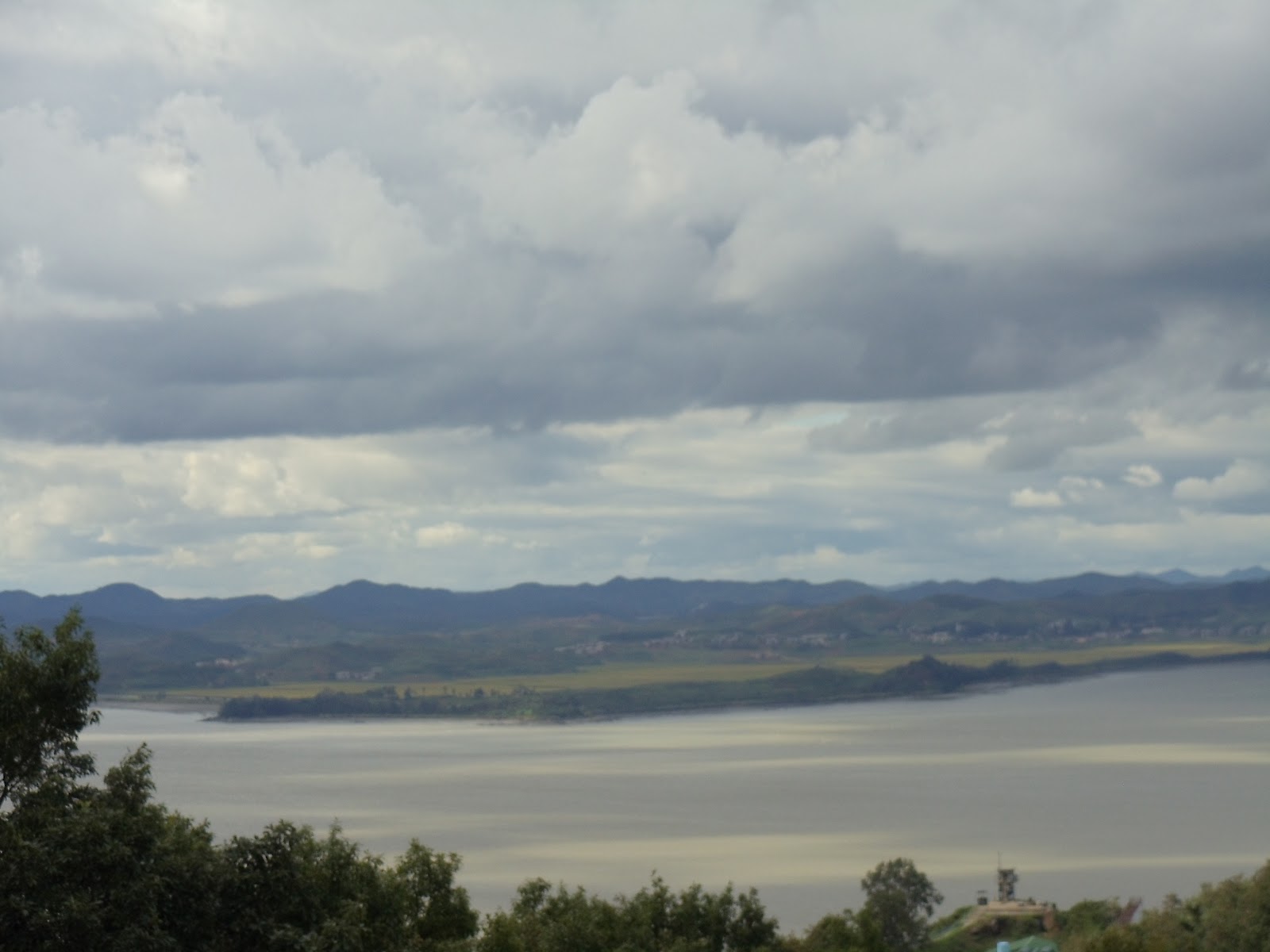
The beautiful view of North Korean mountains.

.  Another view of North Korea
 Another view of North Korea
You guessed it, North Korea, again!


My friend, Jamie, from IOWA!! We met in Iowa City and were able to met up again,
half way around the world. Both on our "big adventures".


Above are panoramic views of South Korea, very industrial. You can see the main road and also the buildings/apartment towers to the left of the picture.
Below are panoramics of North Korea, nearly untouched.


Seoul

Our only picture of Seoul. We are planning an entire weekend trip, just dedicated to seeing Seoul, so not to worry.... More Seoul pictures to come!
That was our trip to the DMZ, wrapped up into 55 pictures. I hope that you are able to come away more enlightened.
Being a history major, I studied all the information of Unification and the Cold War, etc for midterms and finals and forget it the next day. But I will never forget the feeling of sorrow at the Freedom Bridge, the fear of the unknown at the third tunnel or the feeling of hope at the Dorasan station.
Much love,
-C
September 8th, 2012